We're at the San Diego International Airport waiting for our flight. It's now 8:45 this time -- 11:45 by my watch (still bemoaning the time change thing, don't get me started). We board at 10:30, which is really 1:30 in the morning, so I'm sure I'll be half-coherent when I get to my seat. That's fine -- it'll be better for everyone if I'm not too wide awake. The flight is only 4 hours. I thought it would be longer, so that's a delightful surprise. We'll make up for it in Atlanta, though, where we'll have a 4-hour layover before our next flight to Charleston. Ah well. In all, it's not so bad -- in roughly the same amount of time it took us to drive to Augusta we'll be in Atlanta.
No photos to post yet because I'm not sure where the USB cable is to upload the photos. If I locate it before we take off, I'll pop them up -- although it won't be very interesting: just another airport.
It's been a great visit. Lots of time holding, hugging and kissing my grandbaby. The car got here so Connie has wheels. All important. But it'll be good to get home too. I'm sure our poodle and cats miss us.
More later if time allows...
Friday, July 6, 2007

The Left Edge
The little berry Ion made it to the "other" coast:

Note the hill -- we from the Lowcounty call this a mountain -- right beside the ocean. Toto, I don't think we're in Kansas (or South Carolina) anymore.


Note the hill -- we from the Lowcounty call this a mountain -- right beside the ocean. Toto, I don't think we're in Kansas (or South Carolina) anymore.

Wednesday, July 4, 2007
Why the Trip Was Worth It
This beautiful face:
 Who wouldn't willingly and eagerly travel about 2,600 miles to see this smile?
 Who wouldn't willingly and eagerly travel about 2,600 miles to see this smile?
I-40 Philosophy
I'm sure most of you are acquainted with how the road is a metaphor for life -- as in: We travel the road with other passengers, viewing the scenery, taking the occasional detour, etc.
OK, I won't bore you with that tired old saw, but I will relate this experience from the road, which happened more than once: We would be going down the road, moving up a rise in the road, and we'd get to the top and suddenly see the most beautiful landscape. It was so moving that all we could say was, "Wow. Oh my gosh, look at that ... Wow!" And we talked about how awesome God is to create such things.
At one point, I said, "I can't wait to see what's over the next hill." I also said -- actually out loud -- that it was boring to have miles and miles straight ahead where I could see the road and know what was coming and that I would rather be surprised with hills and curves in the road.
Now, the remarkable thing is that I usually -- in my everyday life, I mean -- want to know exactly what's coming. I've even complained that I'm always asking God for the road map so I know what to expect. So to say that I preferred essentially the opposite was quite telling.
And it gives me something interesting to ponder about my basic approach to life.
Monday, July 2, 2007


Images of the Trip
This is what we saw just outside Albuquerque. It looked like we were going to run right into the mountain. No worries: the road turned just before we did.

This is what most of New Mexico and Arizona looked like. We don't have mountains like this back East.
Here we are at the continental divide in New Mexico, elevation 7,245 feet. Rainfall runs to the Atlantic on the right side and to the Pacific on the left side. Beyond this point, we are officially in the West.

Here we are at the continental divide in New Mexico, elevation 7,245 feet. Rainfall runs to the Atlantic on the right side and to the Pacific on the left side. Beyond this point, we are officially in the West.

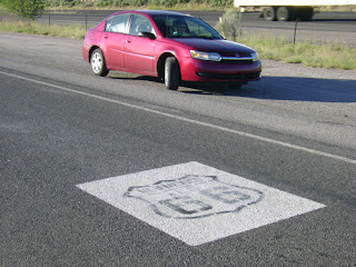
We took this shot at the continental divide. Here's Connie's car on historic Route 66. They make quite the to-do about this highway, let me tell you. Every few miles there was an exit to get on to Historic Route 66. We decided to do a vacation traveling this route. Not anytime soon, though. Later, after we've recovered from this trip.
 This was the view for most of the way -- behind a truck with a mountain looming in the distance.
 This is just beyond the Arizona/California border -- just before we reached Needles, CA. The temperature reached 115.

 This was the view for most of the way -- behind a truck with a mountain looming in the distance.
 This is just beyond the Arizona/California border -- just before we reached Needles, CA. The temperature reached 115.

The Same, Only Different
Well, now that we're at the left coast (photo to come as soon as we actually get to the ocean), I have to say that most of the trip was the same. The highway looks pretty much the same all along the route, with a few exceptions (mountains versus flatlands, for instance), but when I uploaded the photos from Tony's camera -- mine is still in a coma -- it's difficult to tell exactly where we were in a given photo. It's all the same.
But different too. There were times when we'd be heading up a rise in the road, get to the top and just gasp at how beautiful the landscape was spread out before us. The scenery got more interesting after Albuquerque -- no offense, Texas, Oklahoma, Arkansas, Tennessee, Mississippi, Alabama, Georgia and South Carolina; it's just that we'd already seen what those states had to offer. The mountains in the west are different from anything we'd ever seen. (At least in person.) Absolutely gorgeous.
And then we just kept seeing them. Again and again, for miles and miles. We stopped taking photos because we were on overload with rust-colored plateau-shaped mountains.
Then we hit the desert, another thing we'd never seen before. And let me tell you: it's hot. When we got to California, the gauge in the car that tells the external temperature was reading 115. No kidding. And virtually no humidity. When we stopped to get gas, it was extremely hot when we got out of the car, but we didn't sweat. That's just weird.
As for traffic and delays, we had none except a minor slowdown outside of Little Rock and a traffic accident that slowed us down at Flagstaff. The only time we hit aggravating traffic was just outside San Diego. It rained on us only a few times, and then only for 10 minutes at a time. We were very fortunate. The great traveling weather is probably how we could get here in 3 days.
Photos with captions in the next post.
Sunday, July 1, 2007
We're Here!
Finally made it to San Diego by 7:30 their time, 10:30 my time. I'm still messed up with that time change thing.
I'm going to have to backtrack on the posting and let you know how the trip went. For now, I'm busy holding Alexis.
More later, including photos...
I'm going to have to backtrack on the posting and let you know how the trip went. For now, I'm busy holding Alexis.
More later, including photos...
On the Road Again...
My watch says it's 7:00 a.m. but it's really 5:00 a.m. here (see? this is just confusing ... should I be groggy or not?), and we're getting on the road in a few minutes.
Did I mention how technologically prepared we are? We have our cell phones, my travel laptop, cameras with USB cables to upload photos and a DVD player with an assortment of DVDs. (Don't worry, the driver just listens to the movie.) I'm glad this isn't a camping trip because I have no idea how to rough it.
Did I mention how technologically prepared we are? We have our cell phones, my travel laptop, cameras with USB cables to upload photos and a DVD player with an assortment of DVDs. (Don't worry, the driver just listens to the movie.) I'm glad this isn't a camping trip because I have no idea how to rough it.
Saturday, June 30, 2007
Reflections on Day 2 ... with a Few Photos
I was able to upload some of the photos, but not all. Of course, the ones that didn't make it were the best -- isn't that the way it always is? In looking through the rest, I realized that we have a lot of very boring photos of the highway. I know that at the time we were excited to see mountains -- a typical reaction of people from the Lowcountry -- and we figured "photo op!" But when you see the photo, it's really just the highway with a background that looks vaguely like hills. All of which is to say: I guess you have to be there.
Still -- I know how important the image is, so here are a few things we saw on the way. This is what we saw going through Arkansas:
 Ok, I don't know what this looks like to you, but to us it looks like a nuclear reactor. Scared the hell out of us, so we got out of Arkansas as fast as we could. Also, we decided that the Eastern side of Arkansas is boring, but the Western side has a little bit of character, except for the nuclear stuff (if that's what it is).
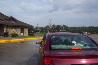
Then we got to Oklahoma, where we saw this at the welcome center. The picnic tables are designed to look like teepees.
Still -- I know how important the image is, so here are a few things we saw on the way. This is what we saw going through Arkansas:
 Ok, I don't know what this looks like to you, but to us it looks like a nuclear reactor. Scared the hell out of us, so we got out of Arkansas as fast as we could. Also, we decided that the Eastern side of Arkansas is boring, but the Western side has a little bit of character, except for the nuclear stuff (if that's what it is).
Then we got to Oklahoma, where we saw this at the welcome center. The picnic tables are designed to look like teepees.

And in case you didn't figure out from those designs that there are Indians (or Native Americans to be politically correct) in Oklahoma, you'll see signs all along the way telling you that you're entering [Indian name] Nation. There must have been 10.
(By the way, I took the photo to include the car so Connie could get excited seeing her car getting closer and closer to her.)
Texas was pretty much like Oklahoma, except "flatter": you could see miles and miles away on either side of the road. Ditto with New Mexico until we got close to Albuquerque and started going through hills and then a mountain as we entered the city. Too bad those photos didn't make it, because they are awesome. (Spoken like a true Lowcountry gal, right?)
In case you're keeping up with the tally, so far we've been through 9 states: South Carolina, Georgia, Alabama, Mississippi, Tennessee, Arkansas, Oklahoma, Texas and New Mexico. 2 more to go: Arizona and California.
Albuquerque
We made it to Albuquerque by about 10:30 p.m. eastern time, although it's 8:30 p.m. here. The time zone change is getting on my nerves. My body has no idea what time it is.
My camera stopped working just before we got here and I'm not sure I can upload photos. If I can I'll post them later.
For now, we have to go forage for food. More details after nourishment...
My camera stopped working just before we got here and I'm not sure I can upload photos. If I can I'll post them later.
For now, we have to go forage for food. More details after nourishment...
Friday, June 29, 2007
6 States in One Day!
Well, we finally got on the road by 6:00 a.m. and made our way to Columbia, then through Georgia, Alabama, Mississippi, Tennessee -- and we're now just outside of Little Rock, Ark. The going was easy for most of the trip -- great weather except for just a few miles of rain here and there -- until we got to Arkansas and ran into traffic. By that time (about 14 hours after we'd started) we figured we'd driven about far enough.
Never thought I'd be able to get from Charleston to Little Rock in one day.
The trip is going well, although it's not exactly sightseeing we're doing. Highways, interstates, 18 wheelers, rest areas -- that's what we're seeing. Oh, and in case anyone was wondering -- so far Alabama has the nicest welcome center.
The only disappointment was the bridge going over the Mississipppi River. I'm not sure what I expected, but after the Cooper River Bridges and the new Ravenel Bridge, this was nothing to write home about.
 Tomorrow we officially get into "the west."
Thursday, June 28, 2007
Almost Ready
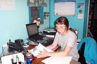
Those of you who know me will recognize this as my natural state -- finishing up an article. This is the last one for this issue, which I am working on at 8:00 at night, and then I can say, "Stick a fork in me; I'm done!" Fortunately my editor will not take me literally.
 P.S. Note the caffeine-free Pepsi instead of my usual Dr. Pepper. Yes, indeed, I had declared myself officially "too wired."
Here's Tony squeezing yet one more box into the car. There's a question of whether we will actually fit.

 P.S. Note the caffeine-free Pepsi instead of my usual Dr. Pepper. Yes, indeed, I had declared myself officially "too wired."
Here's Tony squeezing yet one more box into the car. There's a question of whether we will actually fit.

Wednesday, June 27, 2007
The Right Edge
This, of course, is the Atlantic edge of America: Folly Beach, S.C. Can't wait to see the "left edge" of America. By the way, Connie's stickers on the back window are "Carolina Girl" and "Semper Fi."

Here's one thing I'll miss when I'm away: Charles Towne Landing, where my buddy, Wally the alligator, resides. There he is, swimming behind the "Caution: Alligators" sign. Clever, isn't he?
(For those of you who are new to my blogs, I have a "thing" for alligators. I don't want one as a pet, and I keep a healthy distance from them, but I just view them as the perfect example of being exactly what God made you to be and being happy in it.)
Our Itinerary
Here's the route:
 The points on the map are where we're trying to get to each day: Memphis on Friday, Amarillo on Saturday, Kingman on Sunday and Connie and Josh's door on Monday morning. It's what we're shooting for anyway -- roughly 700 miles each day with about 350 on the final leg.
We're taking I-40 based on advice from both Josh and Andy. They've both made the trip, so we trust them. Specific advice: Josh said there's a steakhouse in Amarillo that's the best in the world. We'll need to call him before we get there and see if he can remember the name. Andy said we should time it so we're going through New Mexico during the daytime to catch the beautiful scenery. Excellent advice on both counts.
We leave Friday morning at about 4:30 a.m. -- yes, there is a 4:30 that happens in the morning. Who knew?
Subscribe to:
Posts (Atom)